Novel analysis unveils complex composition of tea tree oil
 RICE / Monday, 7 August 2023
Share


Agronomy expertise and years of in-field data collection are being combined with real-time satellite and weather data sets to provide practical tools to Australian rice growers which will maximise water productivity, crop yield and overall profitability. Both projects are focusing on the Riverina region of southern New South Wales which produces the bulk of Australia’s rice crops.
The research is funded by AgriFutures Australia’s Rice Program, which invests in research, development and extension (RD&E) to improve the productivity, profitability and sustainability of the Australian rice industry. The two projects underpin the second priority area of the Rice Program Strategic RD&E Plan 2021-2026, Agronomy and Farming Systems, which outlines a pathway for the Australian rice industry to achieve a water productivity target of 1.5 tonnes per megalitre within five years. To reach this ambitious target, whole-of-industry collaboration is needed.
Rice production in Australia varies across each season and region due to differing water allocations, varietal requirements and growing methods. The continued success of Australia’s rice industry will be driven by increased yield and decreased water use through a range of good crop management practices.
The research project Agronomy and remote sensing to maximise rice water productivity is led by research agronomist Brian Dunn from the New South Wales Department of Primary Industries (NSW DPI). It gathers essential agronomic, nitrogen and rice crop management data and combines it with information collected and validated over several seasons to produce practical growing guidelines for new release and current rice varieties that maximise water productivity.
In particular, the project provides valuable recommendations to growers on nitrogen and water management through crucial crop growth stages such as panicle initiation, flowering and maturity. This includes guidance on the rate and timing of topdressing nitrogen during these growth stages to maximise yield and reduce variability within the field.
“Rice is different to other crops – we don’t have a soil nitrogen test for rice because it’s flooded for most of its growing period,” Brian said.
“The research can allow producers to see the variability in their field in the mid-season and ensure nitrogen is applied at the right place, the right time and the right amount to even up the productivity across the whole field.
“We’re also looking at changes to phenology from managing irrigation differently (such as a fully flooded aerial situation versus drill sown versus delayed permanent water). Using water productively is the bottom line and what we’re trying to improve the most.”
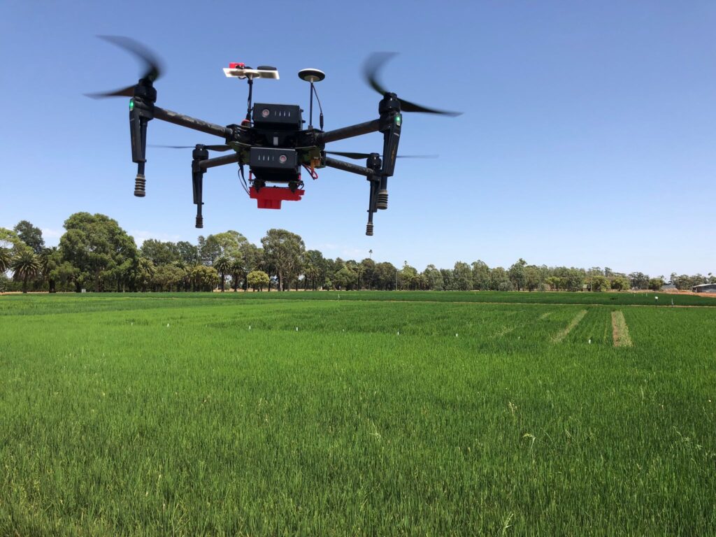
The researchers use a combination of remote sensing technologies and in-field sampling to collect the data and ground-truth the results. Remote sensing is a type of geospatial technology that gathers information about the Earth without making physical contact with its surface using instruments such as satellites, aeroplanes, drones and tractor implements fitted with sensors.
“Satellites regularly capture image data from our sites, and we physically sample the plots to measure biomass and the nitrogen content and build relationships between the physical sampling of the plot and the remote sensed data,” Brian said.
In tandem, Associate Professor Dr James Brinkhoff from the Applied Agricultural Remote Sensing Centre (AARSC) at the University of New England (UNE) is leading the research project Real-time remote-sensing based monitoring for the rice industry. It brings together remote sensing, weather and field observations, and develops models that can help growers predict the growth stages of their rice crop and make more informed management decisions throughout the season.
“We’re bringing all of the data (from NSW DPI) and putting it together with weather information and remote sensing information to see the relationship between what the satellites are observing, the accumulated temperatures over a season and how that guides or dictates when rice gets to different growth phases and levels of maturity,” James said.
“We’ve developed a model which predicts when producers have applied water, which is a really important metric for the growth stage models as well as sustainability. Growth stage models include panicle and initiation and flowering, which are important to guide fertiliser application timing and water levels. We’ve got models to predict rice maturity, which guides decisions around when growers can drain the water off their fields and when they can harvest. We’re continuously improving these models with new information.
“Because the satellite and weather data is available over every field, we can roll out these models to every single field and provide industry-wide analysis so that’s a great benefit.”
This information will be presented in a suite of real-time monitoring tools and alerts for producers to improve their rice management decision making and benchmarking. So far the project has produced an automated map for all rice fields in the Riverina region, and producers and agronomists have tested a web-based dashboard with daily updates on their crop.
“They really see the value of this new source of information for their decision making around nitrogen management, water management and harvest management,” James said.
“Extension is going to be really important in the coming seasons as more confidence is built in the models and predictions, so we can put these tools in the hands of producers and make sure it’s really easy to interpret and put into practice.”
Both Brian and James noted the value of collaboration across the two projects as the data from NSW DPI is key to ground-truthing and validating UNE’s grower-facing models using remote sensed data.
“Our team collects a lot of information across a lot of fields and different water management practices,” Brian said. “When we work with someone like James who has that next level of technology, he can value add that and we get much more out of it, so it’s of much more benefit to the growers.”
James added: “We don’t have the resources to be out in the field every day, or the expertise of Brian and his team. Ground-truthing is such a valuable thing to validate what’s happening in the field.”
To keep up to date with the latest research, events and program activities subscribe to AgriFutures Rice Program here
To hear more about these projects, listen to the AgriFutures On Air episode here
TEA TREE OIL / 07.08.23  WORKFORCE AND LEADERSHIP / 07.08.23
  EMERGING INDUSTRIES / 07.08.23
WORKFORCE AND LEADERSHIP / 07.08.23
EMERGING INDUSTRIES / 07.08.23
WORKFORCE AND LEADERSHIP / 07.08.23
Novel analysis unveils complex composition of tea tree oil
‘George the Farmer’ founder Simone Kain talks Bluey, staying motivated and what she’s doing now
A superfood renaissance down under: AgriFutures Australia announces new research plan for the quinoa industry
Belle Binder wins Tasmanian AgriFutures Rural Women’s Award